
Illustration

A satellite image of the region of the eastern Mediterranean variously known as Canaan, Phoenicia, Palestine and Israel throughout history.
License & Copyright
 Based on Wikipedia content that has been reviewed, edited, and republished.
Original image by NASA. Uploaded by Mark Cartwright, published on 25 October 2018. The copyright holder has published this content under the following license: Public Domain. This item is in the public domain, and can be used, copied, and modified without any restrictions. Please note that content linked from this page may have different licensing terms.
Based on Wikipedia content that has been reviewed, edited, and republished.
Original image by NASA. Uploaded by Mark Cartwright, published on 25 October 2018. The copyright holder has published this content under the following license: Public Domain. This item is in the public domain, and can be used, copied, and modified without any restrictions. Please note that content linked from this page may have different licensing terms.
Related Images
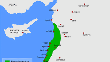
Map of Phoenicia
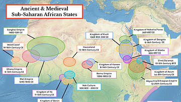
Map of Ancient & Medieval Sub-Saharan African States

Ruins of the Lion Temple in Jaffa
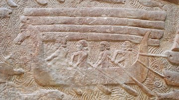
Phoenician Small Ship

Phoenician Religious Sacrifice
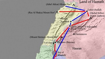
Map of Canaan
Cite This Work
APA Style
NASA, . (2018, October 25). Satellite Image of Canaan-Palestine-Israel. World History Encyclopedia. Retrieved from https://www.worldhistory.org/image/9382/satellite-image-of-canaan-palestine-israel/
Chicago Style
NASA, . "Satellite Image of Canaan-Palestine-Israel." World History Encyclopedia. Last modified October 25, 2018. https://www.worldhistory.org/image/9382/satellite-image-of-canaan-palestine-israel/.
MLA Style
NASA, . "Satellite Image of Canaan-Palestine-Israel." World History Encyclopedia. World History Encyclopedia, 25 Oct 2018. Web. 19 Apr 2024.