Albania is located at the crossroads of the eastern Adriatic and was known as Illyria and Epirus throughout the Classical era. It played a strategic role in ancient times and was a point of contact between Illyrian, Greek, and Roman civilizations. Even though Albania is off the mainstream tourist trail, the country is now emerging as one of the most enchanting corners of Europe.
More tourists visit Albania every year, drawn to its spectacular and unspoiled natural wonders, its rich history, and extraordinary archaeological heritage. Dubbed the “Pearl of the Balkans”, Albania offers a captivating journey through time, with 3,000 years of untouched archaeological heritage.
Archaeological sites such as Apollonia, Antigoneia, and Byllis hide a wealth of historic value, while the Butrint National Park, famed for its ruins and beauty, was recognized by UNESCO as a World Heritage Site in 1992 CE. If you happen to travel to the lands of Southern Illyria and Northern Epirus, read on for some unmissable destinations.
Magazine Syndication

Durrës
Situated on the eastern coast of the Adriatic, Durrës was the first Greek settlement established in Illyria. The area was settled at the end of the 7th century BCE by people from Corinth and Corcyra (modern-day Corfu). The ancient polis (city-state) known at the time as Epidamnos, flourished during the 4th and 2nd centuries BCE and became a very important port.
Due to its strategic location as a harbour, the city played a part in the origins of the Peloponnesian War in the 430s BCE. It also became the theatre of military operations during the civil war that was fought between Julius Caesar (100-44 BCE) and the army led by Pompey (106-48 BCE) in the 1st century BCE.
Epidamnos came under Roman protection in 229 BCE and its name was Latinized to Dyrrachium. The Via Egnatia, the roadway built in the second half of the 2nd century BCE that connected Rome with the eastern provinces of Illyricum, Macedonia, and Thrace, started in Dyrrachium.
The Roman orator Cicero (106-43 BCE), who stayed there in 58 BCE, referred to Dyrrachium as an “admirable city” (admirabilis urbs) because of its temples, statues, and other monuments. The poet Catullus (84-54 BCE) called it “the tavern of the Adriatic” (Dyrrachium Hadriae tabernam).
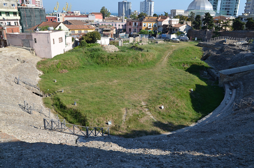
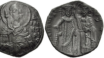
Dyrrachium received the status of a colony under Roman emperor Augustus (r. 27 BCE - 14 CE) and thrived on commerce. The city continued to flourish under the Byzantine Empire (330-1453 CE), but in the Middle Ages, Dyrrachium suffered many attacks. The remains of the ancient city include the Roman amphitheatre, the Byzantine forum, and various fortifications.
The amphitheatre of Durrës, built in the 2nd century CE and discovered only in 1966 CE, is among the largest monuments of antiquity to have survived on Albanian territory and is believed to have held 15,000 to 20,000 people. Used for performances until the end of the 5th century CE, the monument was later the site of a Christian chapel that contains the only wall mosaics that survive in Albania. The city's Archaeological Museum displays a large number of valuable archaeological findings and is also well worth a visit.
►DID YOU KNOW?
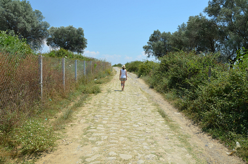
A 100 m-long portion of the Via Egnatia can be seen near the provincial town of Peqin, between Durrës and Elbasan. The pavement is about six metres (20 feet) wide with an Ottoman surface, a later repair of the earlier Byzantine and Roman pavements. A single-arched Roman bridge that supported the Via Egnatia can also be seen.
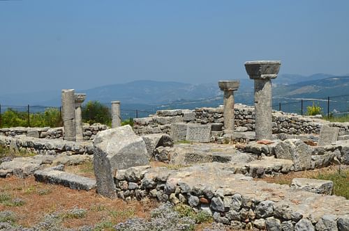
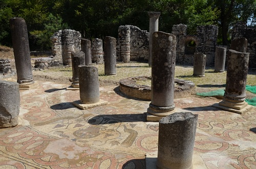
Apollonia
Lying 60 km (37 miles) to the South of Durrës, in the Fier County, is another Corcyraean colony - Apollonia. Taking its name from the god Apollo, Apollonia was the second Greek settlement founded on the Illyrian mainland after Epidamnos.
Greek settlers coexisted here over the centuries with the Taulantii, the Illyrian tribe who inhabited the area. Apollonia stood on a hilly plateau overlooking the Aoös River just a few kilometres from the sea. This strategic position, commanding a view of the surrounding fertile plain, enabled communication with the coastal part of the territory. The city grew rich from the slave trade and local agriculture. It became one of the most important economic, political, and cultural centres of the region.
Like its rival Dyrrachium, Apollonia was also one of the starting points of the famous Via Egnatia. Cicero described Apollonia as “a great and important city” (magna urbs et gravis), and it was while studying rhetoric in the city that Octavian (63 BCE - 14 CE) heard of the death of his adoptive father Julius Caesar.
Archaeological excavations have shown that the city reached its zenith around the 4th and 3rd centuries BCE, with about 60,000 inhabitants living inside the city gates. At the beginning of the 3rd century CE, Apollonia was largely destroyed by a powerful earthquake, and the city was slowly abandoned. By Late Antiquity, the city had largely been depopulated, hosting only a small Christian community.
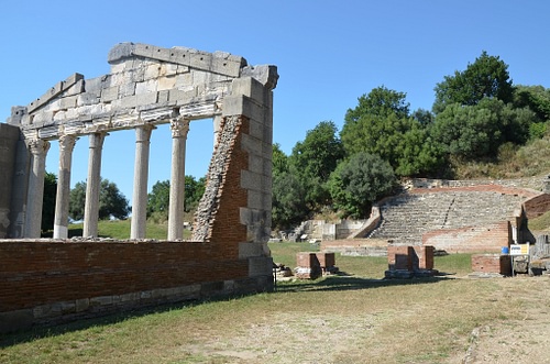
Although only about ten percent of the city has been excavated to date, the remains of Apollonia are considerable, covering an area of 2 km² (0.8 mi²). Visitors can roam around a variety of impressive monuments including a bouleuterion which served as an assembly place of the council of the city; an odeon which would have hosted cultural and musical events; a Greek theatre built in the 3rd century BCE that could accommodate an audience of 10,000; a large stoa (a public covered walkway) built in the 4th century BCE; as well as a rectangular nymphaeum (a monument dedicated to the Nymphs) built in the middle of the 3rd century BCE, which is the biggest and best-preserved monument of Apollonia.
The museum of Apollonia is located inside an Eastern Orthodox monastery and displays artefacts found at the site. It is full of well-presented information about the history of the ancient city and its excavations.
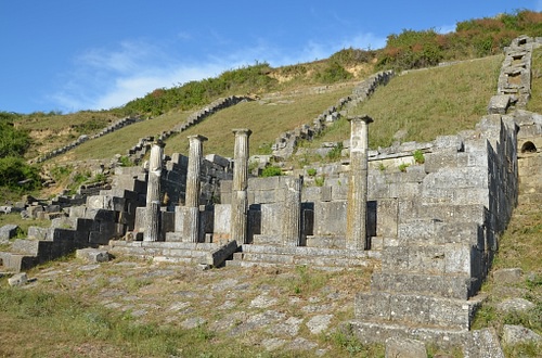
Byllis
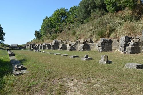
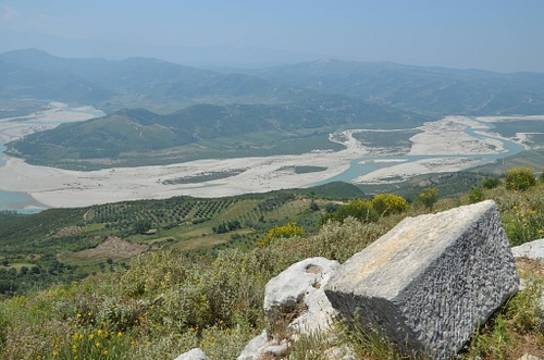
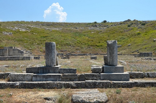
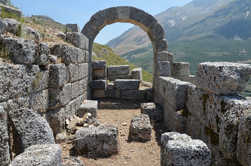
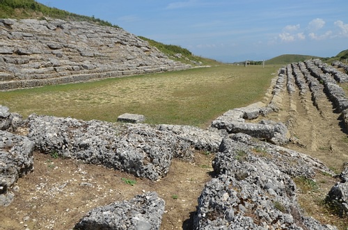
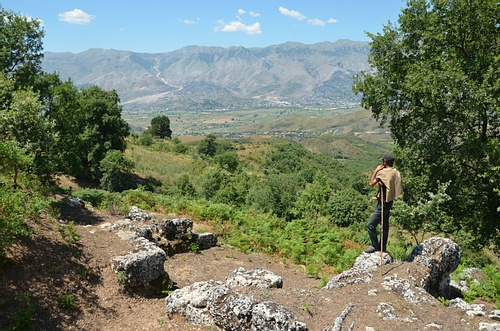
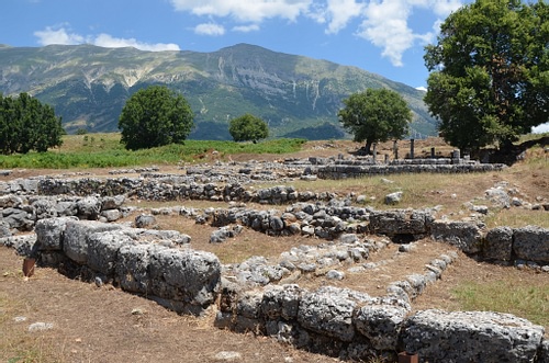
Farther south of Apollonia lie the ruins of the Illyrian settlement of Byllis, one of the most important archaeological sites in Albania. Founded by the Bylliones, a Hellenized Illyrian tribe, in the middle of the 4th century BCE, Byllis was the largest city in Southern Illyria. It occupied a dominant position on the summit of a hill, over the road from Apollonia to Epirus and into Macedonia.
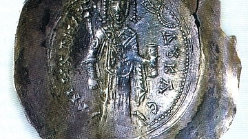
The Bylliones had a sophisticated system of government, minted their own bronze coinage and controlled an area of about 20 km² (7.7 m²). They made Byllis their capital and fortified it with a circuit wall around two kilometres long. Byllis adopted a fully Hellenized regular street-plan which included a theatre, stoas, stadium, gymnasium, and temples. The Bylliones flourished until 229 BCE when the Romans landed in Apollonia and their territory became a field of battle between the Roman army and the Macedonians for the control of Apollonia.
In 49-48 BCE, during Caesar's civil war, Byllis surrendered to Julius Caesar and became a supply base for his army. The city was later turned into a Roman colony, shown by several Latin inscriptions referring to it as Colonia Iulia Augusta. The city walls were rebuilt, the theatre and stoas were reconstructed, and other monuments were erected.
Byllis was attacked and sacked by the Visigoths towards the end of the 4th century CE but the city was reconstructed under Theodosius II (408-450 CE). It suffered a further attack and was again reconstructed under Emperor Justinian I (r. 527-565 CE).
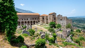
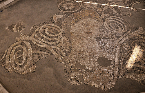
During Justinian's reign, Byllis became an important religious centre and the seat of a bishopric. Several large Palaeochristian basilicas (churches) were built, all of them featuring lavishly decorated mosaics. Sadly for visitors, all the mosaics are covered by protective layers of sand and are not visible. In 586 CE, Byllis was abandoned, and the seat of the bishopric was moved to Ballsh, preserving the name of the old city.
With its fascinating ruins amid stunning views over the Vjosë Valley (Aoös in Greek), the ancient city of Byllis is one of the numerous hidden treasures of Albania. The remains include an impressive theatre, several Byzantine basilicas paved with outstanding mosaics, Illyrian private houses, and Roman public buildings.
Amantia
Crossing the Aoös River from Byllis leads you to the ruins of the ancient city of Amantia, which is located 32 km (20 miles) northeast of the town of Vlorë, Albania's first capital, and the administrative centre of the Vlorë County. Founded around the middle of the 5th century BCE, Amantia was the historical capital of the ancient Greek tribe of the Amantes. It occupied an important defensive position above the Aoös River valley, along the road leading to the coast and to the Bay of Aulon (today's Bay of Vlorë).
Amantia was built on the slope of a high hill covering an area of 13 hectares (32 acres). The city was protected by a 2,100 m long (6,900 feet) walled enclosure equipped with three monumental gates. The settlement extended along the sides of the steep hill. The best-preserved monument of Amantia is the stadium, which was constructed on a natural terrace in the first half of the 3rd century BCE and could accommodate about 4,000 people.
On the southern side of the city, outside the walls, stood a religious complex with a platform for a collonaded Doric-style temple dedicated to Aphrodite. A series of monumental tombs are also in the vicinity. Amantia remained a small urban centre and was the seat of a bishopric in early Christian times. The temple of Aphrodite was demolished, and a Christian basilica was built near the ruins using its materials. It is thought that the city may have been abandoned by the end of the 6th century CE.
Antigoneia
The ruins of the ancient city of Antigoneia stand on top of a hill overlooking the beautiful Drinos Valley that connected Illyria to the north and the Kingdom of Epirus to the south. In 295 BCE, the king of the Molossians, one of the three main tribes of Epirus, founded a city and named it after his wife Antigone, daughter of Berenice I (c. 340 - c. 268 BCE) and step-daughter of Ptolemy I (366-282 BCE) of Egypt.
The Molossian king was the famed Pyrrhus whose battles against the Roman Republic would come to be known as 'Pyrrhic victories' (a victory gained at too great a cost).
With such a strategic position, Antigoneia became an important economic, political, and administrative centre for more than a hundred years until its destruction in 167 BCE, at the end of the Third Macedonian War, which devastated Epirus. The thick layer of burning found throughout the excavated areas shows that the city was destroyed violently. Under the Roman consul Aemilius Paullus (c. 229-160 BCE), 70 cities in Epirus were sacked and set on fire. This probably included the city of Antigoneia which was never rebuilt.
The significance of the site was largely unknown until the ancient town was excavated and identified by the Albanian archaeologist Dhimosten Budina (1930-2004 CE) and the discovery of bronze tesserae bearing the inscription “ANTIΓΩNEΩN” (of the citizen of Antigoneia) in 1968 CE.
The city was built on the Hippodamian grid system and covered an area of almost 45 hectares (111 acres). It flourished through trade with the other Hellenistic cities, and with Illyria and Macedonia. The remaining structures of this short-lived city include the city's fortification walls, the agora, prytaneum, residential houses with peristyle courtyards, workshops, as well as a Paleochristian church with mosaic floors (sadly, kept covered).
Since 2005 CE, Antigoneia has been organized as a National Archaeological Park with information panels placed around the park to inform visitors of the various monuments. Excavations are still underway, and most of the finds are displayed in the National Historical Museum and National Archaeological Museum in Tirana.
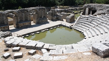
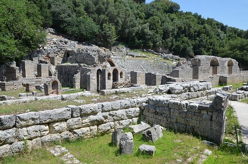
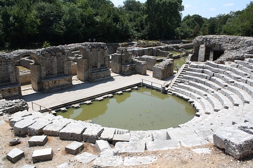
Butrint
As Albania's first designated UNESCO World Heritage Site, Butrint (ancient Buthrotum) is the most famous and most-visited archaeological site in the country. Located opposite the Greek island of Corfu, Butrint offers a combination of historic ruins and natural beauty. Its well-preserved ruins are nestled in a marshy landscape of exceptional beauty and tranquillity between an inland lagoon and the Ionian Sea and surrounded by densely forested hills. The remains of the ancient city span 2,500 years from the Greek, Hellenistic, Roman, and Christian periods to even the Venetian period. The earliest archaeological evidence of settled occupation dates to between the 10th and 8th centuries BCE, although the legend associated with its origins speak of the city's foundation by Trojan exiles.
In the Aeneid, the Roman poet Virgil (70-19 BCE) describes Butrint as having been founded by the Trojan prince Helenus, a son of King Priam of Troy and like a “Troy in miniature” (parva Troia) to the hero Aeneas who stayed there after his own escape from the destruction of the city in the Trojan War.
Buthrotum appears in written sources during the 6th century BCE when the city was a small acropolis under Corcyraean control. The city grew in importance and developed its trade thanks to its access to the Straits of Corfu.
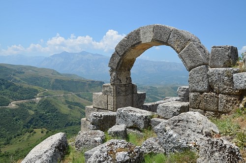
The situation changed radically at the turn of the 4th century BCE when the Molossians invaded the coast of Northern Epirus. The city was fortified with a new 870 m long (2,800 feet) wall and numerous gates. By the late to mid-3rd century BCE, the settlement included a theatre that could accommodate about 2,500 people, an agora, and a sanctuary dedicated to the god of healing, Asclepius.
Due to its favourable location, Buthrotum played an important role in Caesar's civil war in 49-48 BCE and served as a base for Caesar's army. In 31 BCE Augustus, fresh from his victory at the Battle of Actium, established a Roman colony and the city expanded considerably and remained an important road-station on the way to Nicopolis, the capital city of the Roman province of Epirus Vetus. The Roman forum was constructed in the Augustan period, while the city witnessed its greatest period of prosperity in the 2nd century CE. Numerous Roman baths, fountains, and public buildings were constructed, and the theatre was renovated.
The town suffered much damage from an earthquake sometime in the 4th century CE but survived into Late Antiquity, becoming the seat of a bishopric with Christian buildings including a large basilica and a baptistery, one of the largest such Paleochristian buildings of its type. The city then went into a long decline and was abandoned until 1928 CE when the Italian authorities sent an expedition to Buthrotum.
The archaeological site is at the heart of the Butrint National Park which was established in 2000 CE to preserve the natural ecosystems and woodland. A network of walking trails passes through this rich Mediterranean habitat and leads visitors to the many historical buildings. The finds from the site are on display in the small museum located on top of the hill where the acropolis of Buthrotum once stood.
Many of the country's archaeological treasures are housed in the largest museum in Albania, the National Historical Museum in Tirana. Other archaeological finds can be seen in the National Archaeological Museum, also located in Tirana.
This article was originally printed in issue 15 of Ancient History Magazine.